
About us / Mission
Mission
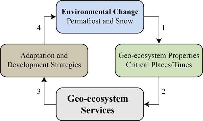
What are the implications of rapid environmental change in Canada and the circumpolar North caused by thawing permafrost and changing snow conditions? How will we cope? These changes are affecting landscapes, water and wildlife, as well as the northern communities and industries that depend on these resources. The ADAPT mission is to produce an 'Integrated Permafrost Systems Science' framework that will be used to help generate sustainable development and adaptation strategies for the North in the context of rapid socio-economic and climate change.
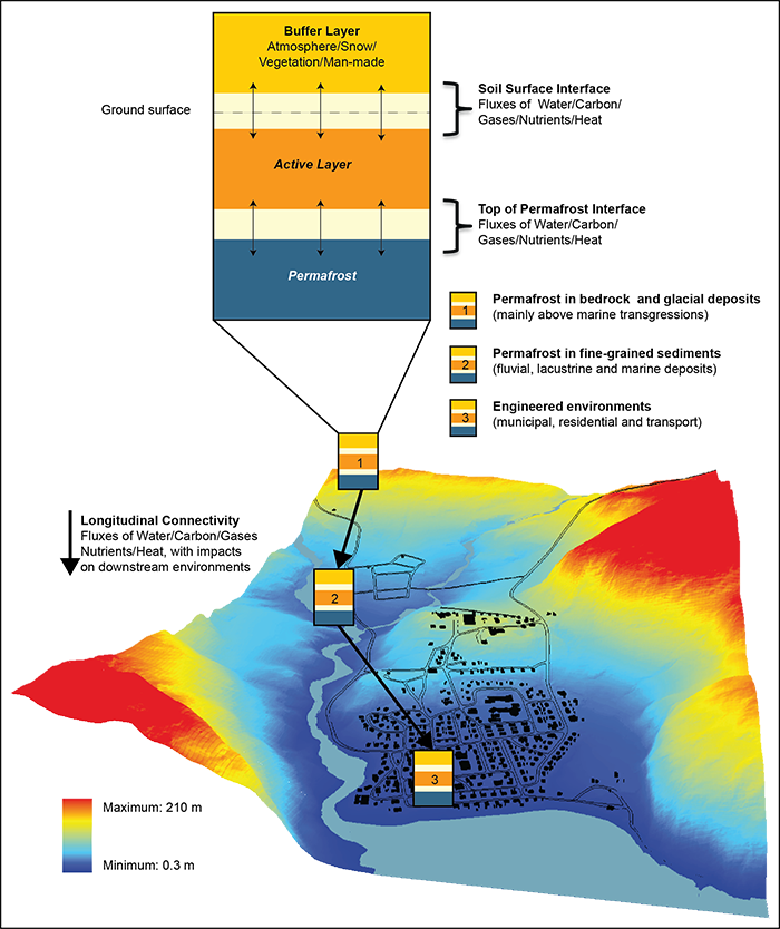
ADAPT 3-Layers Model
Each project within ADAPT is connected to the overarching geosystem/ecosystem/human system model shown above, and also to a 3-layer depiction of the permafrost environment. The ADAPT Integrated Permafrost Systems model based on the central role that plays liquid water in driving heat, sediment, carbon and microbial transport and in affecting thermodynamic stability and geomorphological processes in permafrost landscapes. The model is composed of 3 layers and 2 interfaces: the Atmosphere-Snow/Vegetation layer (referred to often as the buffer layer), the near surface soil-water-microbes processes interface, and the active layer, the top of permafrost interface and the permafrost layer. For applied questions, the buffer layer can be replaced by man-made infrastructures. Developing this model require ongoing conceptualisation by the ADAPT team, definition of model parameters, and mathematical simulations to be validated with field data. In support of this work, a new Integrated Advanced Multi-Technological (IAM-Tec) instrument is being developed for permafrost characterization at local and regional scales. New technologies are being applied such as Distributed Temperature Sampling (DTS) using fibre optic sensors in the natural environment and along linear, engineered infrastructure (e.g., roads built on permafrost), new experimental concepts and protocols to study and measure heat fluxes (radiative and conductive) and water tracks in permafrost, and Interferometric Synthetic Aperture Radar (InSAR) imagery, a remote sensing technique that provides measurements of terrain deformation at a sub-centimetre scale over time spans of days to years. These technologies are integrated via a permafrost risk mapping approach that also uses conventional methods and technologies (e.g., Ground Penetrating Radar, electrical resistivity surveys, drillings, core sampling and borehole thermistor cables, stratigraphic and shallow geophysical surveys and grain size analyses), with the data synthesized as information layers that are integrated and collated in a Geographic Information System (GIS) data base.
![]()
![]()
![]()
![]()
![]()